New 3D models of Baxter State Park to give visitors a new perspective
This spring, new 3D terrain models of Baxter State Park will be installed throughout the park at visitor centers, campgrounds and ranger stations for the public to use while planning their backcountry adventures.
Donated by Friends of Baxter State Park, these state-of-the-art displays were produced by Solid Terrain Modeling, the same company that makes terrain models for the National Geographic Explorers Hall and Smithsonian Institution.
“It’s been in the works for a long time,” said Aaron Megquier, executive director of Friends of Baxter State Park. “We started thinking about doing this eight or nine years ago.”
The donation consists of 10 models, which cost $65,000, making it the largest single donation Friends of Baxter State Park has ever made to the park.
Six of the models are 3-by-3-foot representations of Katahdin, the tallest mountain in Maine and most celebrated and visited landmark in the park. These models will be installed at Roaring Brook, Abol, Katahdin Stream, Baxter State Park headquarters, and the Park Visitor Center at Togue Pond, with an additional Katahdin model kept as a spare.
The other four models are: one covering all of Baxter State Park, measuring 3 by 6 feet, to be installed in the Park Visitor Center in Millinocket; one 3-by-3-foot model of the Traveler Range, to be installed at South Branch Pond; and two 3-by-3-foot Katahdin models designed for travel, with armored edges and rolling carrying cases, to be used in education and outreach programs.
“I really think they’re going to help people plan their trips and their time in the park,” Megquier said.
Many longtime park visitors are familiar with the fiberglass Katahdin models that have been on display in the park since the 1980s. While useful, those older models were built on a 3 to 1 scale, with the vertical relief being exaggerated, which significantly distorted the terrain. Also, the old models didn’t cover enough area to include any of the three Katahdin trailheads, so visitors referring to the models couldn’t see the entire length of the trails while planning their treks.
The new terrain models feature more accurately proportioned terrain overlaid by satellite imagery that makes it easy to see the location of treeline, rockslides, bodies of water and other important landscape features. The vertical relief is still slightly exaggerated so that certain details are visible, but the terrain is much less distorted.
“It’s still exaggerated slightly,” said Megquier. “But the reason for doing that is so [that] really small but important features like ravines and gullies pop out more.”
The new Katahdin models are on a 1.25 to 1 vertical scale, the Traveler Range model is on a 1.5 to 1 vertical scale and the model of the entire park is on a 2 to 1 vertical scale.
“I can see just in terms of trip planning there being a huge benefit to having these on display,” said Megquier. “And in search and rescue situations … and I think there will be some benefits for staff in just explaining to visitors where they need to go, how to get there and how long a drive it is, for example, through the park. A lot of those things immediately become clearer when you’re sitting there looking at this 3D model.”
To learn more about Friends of Baxter State Park, a group founded in 2000 with the mission to preserve and support Baxter State Park, visit friendsofbaxter.org.

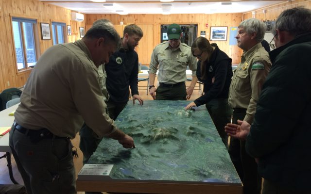
Baxter State Park staff gather around one of 10 new 3D models of Baxter State Park donated by Friends of Baxter State Park in December during the park’s annual staff meeting. The state-of-the-art displays were produced by Solid Terrain Modeling, the same company that makes terrain models for the National Geographic Explorers Hall and Smithsonian Institution.
(Courtesy of Aaron Megquier)