4 lesser-known mountains in Maine you should hike
By Aislinn Sarnacki
Because I’m such an avid hiker, people often ask me if I’ve run out of new trails to explore in my home state of Maine, and the answer is a resounding “no.”
Hundreds of trails criss-cross the landscape, visiting mountains, hills, waterfalls, peat bogs, meadows and ocean cliffs. I haven’t come close to exploring all of these footpaths, though this autumn, I did hike a few new-to-me trails that I’d recommend you try.
First up: Mosquito Mountain in The Forks. In a state that’s home to 45 species of mosquitoes, it’s a rather fitting name for a peak. Plus, when viewing the mountain from afar, I imagine it resembles the many insect bites I’ve suffered over the years.
The mountain is actually named after the nearby Mosquito Narrows, a buggy spot on Moxie Pond, according to the book “Mountains of Maine: Intriguing Stories Behind Their Names” by Steve Pinkham. Cartographers often tie landmarks together in this way.
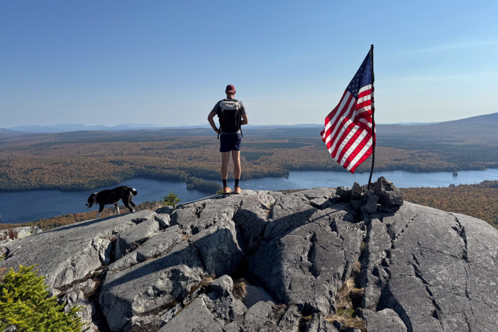
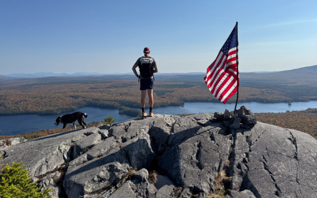
MOSQUITO MOUNTAIN — Chris Bennett and Juno stand at an overlook atop Mosquito Mountain in late September in The Forks.
The hike — about 3 miles out and back — climbs to the open summit of the mountain, which is 2,215 feet above sea level. From ledges at its top, you can enjoy views of Moxie Pond, Moxie Bald Mountain and Big Moose Mountain. Other landmarks visible on a clear day include Moosehead Lake, the Bigelows and Katahdin.
Also near the top, on an open ledge, waves a large American flag on a slightly bent pole. Snapping in the wind, the flag was an unexpected but welcome sight when I hiked the mountain on a sunny day in October.
I cannot, for the life of me, figure out who maintains this trail. I’ve looked through guidebooks and online resources to no avail. So if you know who to credit, please shoot me an email at aasarnacki@gmail.com.
I suspect that local residents who love the mountain are responsible. The trailhead is marked by a simple wooden sign with the mountain’s name and trail mileage handwritten in marker. Early on, near a collection of impressive boulders, a sign warns hikers of the “Spoon Monster.” (Local lore?) And farther up the slope, a “Beware of Gnome” sign hints at another possible danger. I’m happy to report that I didn’t run into trouble.
This is a well-worn trail, but near the top, where it crosses exposed bedrock, I found it easy to wander off track. So, pay attention. Access is free, and dogs are permitted. The parking lot at the trailhead is quite small. Don’t block the road when parking.
Next up: Blueberry Mountain. With Maine being the top producer of wild blueberries in the world, this is another fitting name. Located just north of Weld, this hike is similarly short and steep. But this time, the views at the top are of the nearby Tumbledown Range, Mount Blue, Sugarloaf and the Crockers.
Rising 2,962 feet above sea level, this mountain is partially within the 22,000-acre state-owned Tumbledown Public Lands, but the first half of the trail lies outside of this conserved land, on the property of Blueberry Mountain Bible Camp. This camp and retreat — with buildings just down the road — manages the trail and parking area.
As is the case on many Maine mountains, wild blueberries grow in abundance on Blueberry Mountain, especially near the summit, where the terrain opens up.
Out and back, the hike is just over 4 miles. Access is free, and dogs are permitted. The trail closes for the winter because the camp doesn’t plow the road.
The next peak I explored this fall? Pleasant Mountain in the towns of Bridgton and Denmark. A hiking hotspot due to its proximity to high-population areas in southern Maine, this mountain can be climbed from four different directions. (It’s also home to downhill ski trails where you can enjoy epic nighttime skiing under lights.)
In early November, I hiked up the Ledges Trail, which leads to several open ledges with amazing views on the way to the top. This trail climbs steadily, covering 1,600 vertical feet in under 2 miles. The summit is open, offering views of the White Mountains in the distance, including Mount Washington.
Loon Echo Land Trust oversees the management and stewardship of the 10-mile hiking trail network on Pleasant Mountain. Access is free. Dogs are permitted but must be on leash.
Lastly, I hiked Number 5 Mountain, which is located southwest of Jackman in Number 5 Township (hence the less-than-exciting name). This impressive peak — topping off at 3,156 feet above sea level — lords over The Nature Conservancy’s 16,934-acre Leuthold Forest Preserve.
The preserve features a unique fir-heart leaved birch alpine forest. While hiking up the trail, I picked up several of the newly fallen birch leaves to find that they were, indeed, shaped like hearts.
The area is also home to northern birds such as gray jays and boreal chickadees, both of which I saw during the hike. And moose. While I didn’t spot any of these hulking mammals on my hike, I did step over piles of their poop and I found a chunk of moose hair lodged into the crook of a tree branch. Perhaps it had been using the tree as a back scratcher.
The top of the mountain offers open views of Number 5 Bog, Attean Pond and the nearby Number 6 Mountain, which — you guessed it — is located in Number 6 Township (also known as Appleton Township).
Out and back, the hike is a little over 5 miles. Access is free. Pets are not permitted. And keep in mind that you have to drive for 17 miles on a gravel road to reach the trailhead, so it’s a bit of a backcountry adventure.
So, there it is: four Maine mountains I’d never hiked before this fall. This winter, I’ll try hiking at least four more “new” trails — in addition to returning to some of my old favorites. Any suggestions?