What it’s like to hike Maine’s scariest trail
By Aislinn Sarnacki
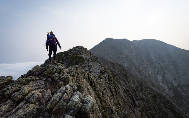
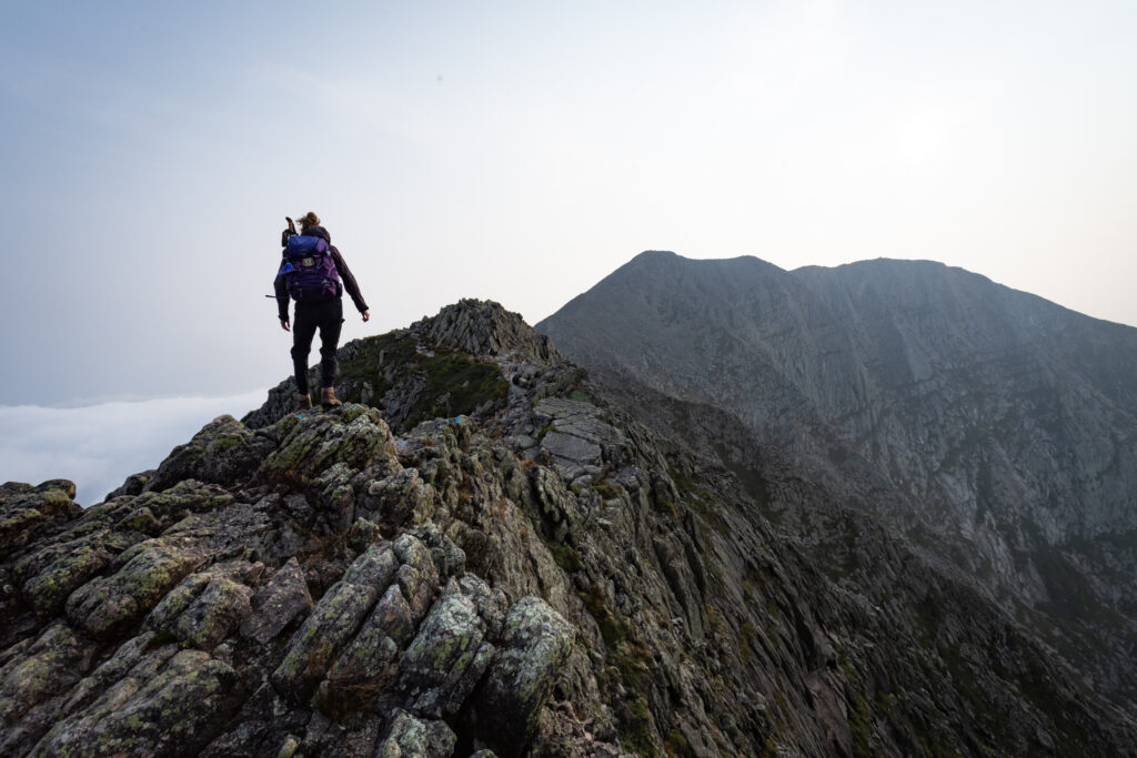
The jagged backbone of a stone giant, Knife Edge stretched before us. On both sides of this narrow ridge, the earth fell away, a near vertical drop of more than 1,000 feet.
It occurred to me then just how ridiculous it was to hike across it. But what’s life without a dash of absurdity? It’s where some of the best memories are born. So I took one careful step, and then another.
I had hiked across Knife Edge before. I was a teenager when I first followed the blue paint that marks the intimidating trail. My mom followed close behind, pleading with me to “get down” closer to the rock and stop hopping around like a billy goat.
The mile-long ridge of sharp granite bridges two peaks atop Maine’s tallest mountain, Katahdin. In some places, it narrows to the width of a sidewalk — a sidewalk winding through the sky.
KNIFE EDGE — Tori Gray of Millinocket hikes across Knife Edge in the afternoon of Aug. 17 in Baxter State Park.
I’ve hiked Katahdin many times over the years, but I’ve only crossed Knife Edge on a few of those treks. You see, several trails lead to the mountain’s summit, allowing you to avoid the scary ridge altogether. If you hike Knife Edge, it’s by choice, not necessity.
Prior to this summer, the last time I hiked across the ridge was 10 years ago with a group of family and friends. Since then, I haven’t avoided it, but my hiking companions have. For those afraid of heights, Knife Edge is an absolute nightmare. It’s not something you push anyone to cross.
I’ve seen plenty of superlatives piled on Knife Edge.
“This route is probably the most spectacular mountain trail in the East,” wrote the author of the Appalachian Mountain Club’s Maine Mountain Guide in 1971.
Some call it the scariest hike in Maine, others claim it’s the most dangerous. I suppose it’s all a matter of perspective. People have certainly been injured while hiking the technical trail — but that holds true for many trails throughout Maine and beyond.
Last September, a 43-year-old hiker broke her ankle while hiking Knife Edge and was airlifted off the mountain. Just a few weeks prior, six hikers were forced to spend the night on the narrow ridge while waiting for rescue. One was lifted off by helicopter, while the rest were helped down the mountain by rangers and a search and rescue team. All made it through OK.
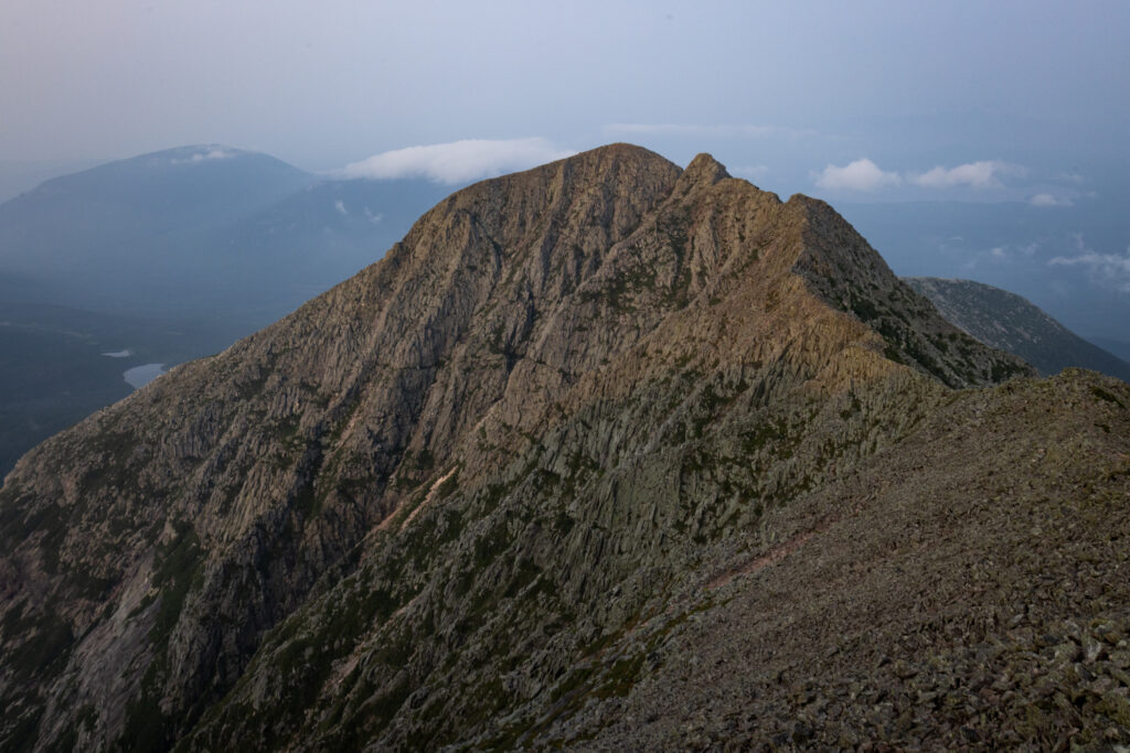
VIEW OF KATAHDIN – The late afternoon sun bathes Katahdin on Aug. 17 in Baxter State Park.
Death on the ridge is uncommon but has occurred.
Katahdin is located in Baxter State Park, which recorded its first death in 1933. Since that time, the park has seen more than 60 deaths, according to “Death on Katahdin: And Other Misadventures in Maine’s Baxter State Park” by Randi Minetor, published in 2018. Only a few have occurred on Knife Edge.
Most recently, in 2020, a journalist from Massachusetts, 75-year old Donald MacGillis, died after a 50-foot fall from the ridge. He’d been hiking with his nephew.
I don’t wish to scare anyone away from this trail, but I want to acknowledge the risks. For me, the risks are worth the reward of exploring the spectacular landmark. But, as I always do while hiking, I try to minimize my risk of injury by carefully planning and packing, then monitoring my health and the weather as I hike.
It’s also wise to hike with a companion or two. For my most recent Knife Edge traverse, I was joined by fellow Maine Guide Tori Gray, who used to work as a ranger in the park. I couldn’t have asked for a more knowledgeable and experienced hiking buddy on Katahdin.
Just getting to the start of Knife Edge takes a great deal of effort. We hiked camping equipment 3.3 miles uphill to a lean-to we’d reserved at Chimney Pond. At the edge of the shallow, crystal clear tarn, we ate sandwiches and Snickers bars, then shed some gear and left a note for the campground ranger. We knew we’d return after dark, and we didn’t want anyone to worry.
Both of us carried headlamps, food, extra layers of clothing, first-aid items and bottles of water that we’d filtered from the pond. We even carried a backpacking stove and pasta, just in case we wanted to enjoy a hot dinner before returning to camp.
Recently rerouted due to a rock slide, the Dudley Trail is 1.9 miles long and leads to Pamola Peak — one of Katahdins many peaks. Named after a spirit and guardian of the mountain celebrated by the area’s Indigenous people, Pamola Peak tops off at 4,902 feet above sea level. That places it a few hundred feet below the mountain’s summit, Baxter Peak, which lies at the other end of Knife Edge and is 5,267 feet.
From the wooden sign marking Pamola Peak, we looked out over Knife Edge. A low blanket of white clouds pressed up against the south side of the mountain, reminding me that we stood nearly a mile above sea level. A warm wind swept over sharp boulders, threatening to toss my baseball cap into a sea of trees far below.
Our traverse was cautious and full of delight. Just past Pamola Peak, the trail dipped into a cleft called Chimney Notch, then climbed steeply to Chimney Peak. The section required hand-over-foot climbing and a bit of faith.
The sinking sun appeared orange as it fought through the haze of wildfires raging in Canada, bathing the mountain in gold.
A mile passes slowly when you’re waltzing over a narrow band of uneven, sole-shredding rock with nothing but open air on both sides. Time crawled, and in places, I also crawled. Gone were the days of the careless billy goat.
In one spot, the especially narrow trail hugged a cliff as it curved around a bend. Tori, hiking ahead of me, appeared to walk off the end of the earth.
During the summer, Baxter Peak is usually surrounded by dozens of people from late morning to early afternoon. It’s a place where hikers rest and celebrate. But because it was so late in the day, we had the unusual experience of having the summit entirely to ourselves.
Standing beside Tori, looking out over the peaks and ponds of Baxter State Park, I felt deeply grateful for my ability to hike to such breathtaking places. “This is my happy place,” I told Tori.
We were considering whether we should stay for sunset when a bank of clouds to the south rose and swept over the Tablelands, blocking out the sun. The mountain was telling us that it was time to go.
Descending on Saddle Trail, we hiked the last half hour by headlamp, notified the Chimney Pond ranger that we were down safe, then tucked into our sleeping bags after a hot bowl of soup. We slept soundly that night, cradled in the arms of Katahdin, below the serrated silhouette of Knife Edge.