Remote Rainbow Loop offers views of Katahdin and a winter workout
By Aislinn Sarnacki
Driving down the wide, snowy Golden Road, I glanced at the blank navigation screen on my car’s dashboard and internally shrugged. I’d lost phone service, but I knew generally where I should look for the trailhead. And if all else failed, I had a paper map.
Just west of Baxter State Park, I passed over Abol Bridge and continued north to the trailheads for Debsconeag Lakes Wilderness Area. My goal was to hike the six-mile Rainbow Loop, a route that officially opened in 2017 and had been on my “places to explore” list ever since.
The Debsconeag Lakes Wilderness Area is a 46,271-acre ecological reserve that’s owned and managed by The Nature Conservancy. Indigenous people named the area Debsconeag, meaning “carrying place,” because of the many trails used to portage canoes from one body of water to another.
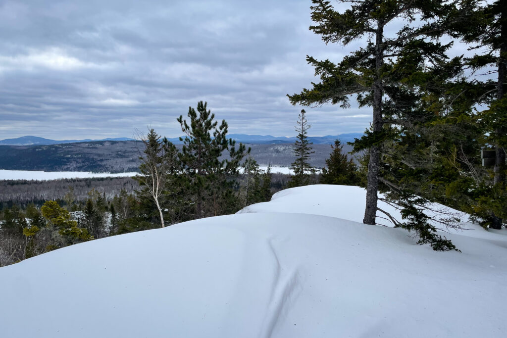
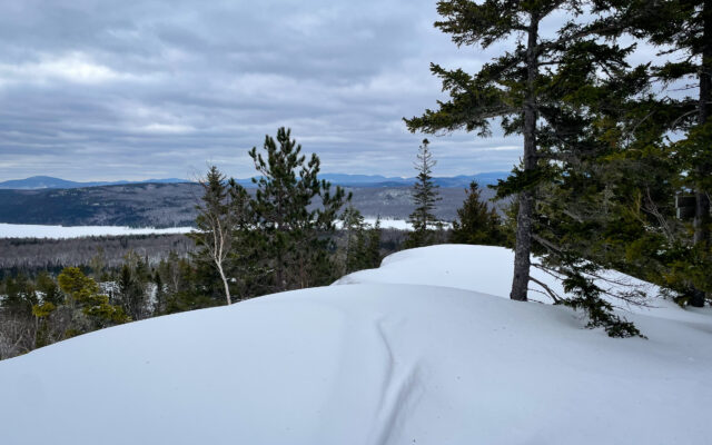
RAINBOW LOOP — A smooth layer of snow covers the ledges of a highpoint in the Debsconeag Lakes Wilderness Area on Feb. 12, on a route known as the Rainbow Loop.
I’d hiked in the reserve before — to visit ice caves and walk the Appalachian Trail to Little Hurd Pond. But the Rainbow Loop was new to me, and it started from an entirely different parking area.
A helpful sign marked the road leading into the parking lot. The road was unplowed. But a small space had been cleared for parking at the end. Squeezing to the side, I left enough room for one other vehicle to fit — just in case someone else showed up to hike.
But I didn’t see a soul all day. It was just me, the trees and a whole lot of snow.
Faint snowshoe tracks marched down the road. Filled with crusty snow, the imprints revealed that someone had hiked the route recently. But it had snowed since, so I’d be breaking trail.
The road led to the summer parking area in just a couple tenths of a mile. There I found a trailhead kiosk with a detailed map, plus a sign with the mileage to various destinations in the trail network: Clifford Pond, Horserace Pond, Woodman Pond and Rainbow Lake.

COVERED SUMMIT — Clouds crowd the top of Katahdin on Feb. 12, as seen from the high point of the Rainbow Loop in the Debsconeag Lakes Wilderness Area.
In addition to visiting pristine, remote bodies of water, the loop travels up and over ledgy hills to overlooks with views of nearby Katahdin, Rainbow Lake and a number of peaks in the 100-Mile Wilderness.
The hike began with a whimsical wooden bridge. Marked with yellow blazes, the trail threaded through a mixed forest for about half a mile before splitting into a loop. I turned left onto the Blue Trail (marked in blue paint), opting to hike the loop clockwise. From there, it was 2.4 miles to a high point and overlook that’s referred to simply as “Summit” on intersection signs.
In some places, I fell through the crust up to my knees. In others, where the trees sheltered the ground, the snow wasn’t as deep.
The task of breaking trail had me shedding layers to avoid sweating too much. First went my down jacket, then my fleece jacket. Before long, I was snowshoeing in a T-shirt, ski pants, gloves and winter hat, my jackets strapped to the outside of my backpack.
The forest was quiet, save for the occasional song of a chickadee or nuthatch. Based on the forecast, I’d expected sunny skies that day. But the clouds crowded in, casting the landscape in a flat, even light.
Just over a mile into the loop, I reached an intersection where I turned right onto the orange-blazed Rainbow Loop Trail. The other option was to continue on the Blue Trail for 1.2 miles to where it ended at the shore of Rainbow Lake. I considered it. But there’s ambitious, and there’s overambitious. I already had miles of crusty snow ahead of me. So I left Rainbow Lake for another day.
Continuing on the loop, I trudged steadily uphill to the first major overlook, then down into the woods to a small pond before climbing up to the “Summit.” At just over 1,600 feet above sea level, the high point has exposed bedrock and ledges with open views.
I looked out over a snowy Rainbow Lake, then turned to the northeast to see Katahdin peeking out from beneath a thick layer of gray clouds, its white slopes glowing in a swath of sunlight. Its majesty never fails to awe me.
From there, it was all downhill — and thank goodness, because I still had more than 3 miles of marching through snow to go. I paused near the shore of Horserace Pond to eat some oatmeal raisin cookies and imagine myself tenting at one of the two backcountry campsites. I also took a moment to admire some of the large boulders scattered across the landscape. But for the most part, I kept moving, slowly but steadily.
Throughout the hike, I came across some especially large hemlock trees. I also noticed an abundance of lichen growing on the trees, from crunchy lungwort to wispy old man’s beard. I hear that’s an indicator of older forests and clean air.
I made it back to the trailhead by 4 p.m., after about six hours of snowshoeing. I had been looking for a workout that day, and it had been the perfect challenge.
As I followed my own tracks back along the unplowed road to my vehicle, I noticed the hoofprints of a white-tailed deer stamped into my tracks. Smart animal. No need for both of us to break trail.