Experience some of Maine’s most challenging hikes without leaving home
Maine is home to some truly challenging hiking trails. Mud, steep slopes, slippery stream crossings, exposed tree roots, ridiculously rocky terrain. Maine has it all, and often hikers must contend with all these things at once. But here’s the thing: It’s worth it.
These rugged footpaths lead to hard-to-reach places that are heartbreakingly beautiful. Crystal clear lakes, alpine meadows and rolling hills of exposed granite. Moss-filled forests, raging waterfalls, giant boulders and secluded cobblestone beaches. Many of these special, remote places can only be seen by taking an arduous trek — or by watching a video.
Right now, to slow the spread of COVID-19, people are practicing social distancing and in some cases, self-quarantine or self-isolation. This may restrict or limit their travel, meaning more time spent relaxing indoors. But thanks to technology, they can still experience the outdoors and its many wonders.

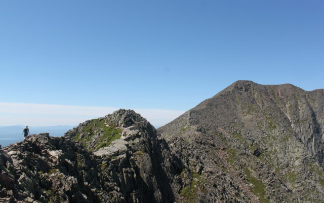
File photo courtesy of Derek Runnells
KNIFE EDGE OF KATAHDIN — Bangor Daily News reporter Aislinn Sarnacki hikes over Knife Edge of Katahdin on July 13, 2013. The ridge becomes just a few feet wide at some points, and the mountain drops away for thousands of feet on both sides.
Over the course of several years, I’ve created more than 300 short “1-Minute Adventure” videos while hiking trails all over the state of Maine. My hope is that the videos serve multiple purposes. For some people, I hope the videos and accompanying columns can inspire and help prepare them for their own adventures. For others, I hope the videos can be a form of entertainment, a way for them to explore places they wouldn’t otherwise go.
So sit back, grab some popcorn and join me in these “1-Minute Adventure” videos as I tackle some of the most challenging hikes in Maine.
1. Katahdin’s Knife Edge
Rising nearly a mile above sea level, Katahdin is Maine’s tallest mountain. Its ridges of jagged granite are a sight to behold, towering over the dense forest and pristine ponds of Baxter State Park. Knife Edge is a narrow and treacherous ridge that spans 1.1 mile between the mountain’s Pamola Peak and Baxter Peak.
2. Precipice
Zigzagging up the cliffs of Champlain Mountain, Precipice Trail is known as the most challenging and dangerous trail in Acadia National Park. In less than a mile, it ascends nearly 1,000 feet. Several sections of the trail are so steep that hikers must be aided with metal rungs, rails and ladders bolted into the granite cliffs. And in many places, the trail is narrow with a vertical rock wall to one side and a sheer drop to the other.
3. Gulf Hagas
Known as the “Grand Canyon of Maine,” Gulf Hagas is a slate gorge carved out by the West Branch of the Pleasant River. Over the course of 3 miles, the river drops about 500 feet, forming several spectacular waterfalls and swimming holes. While this is not a mountain trail, the trail changes elevation quite a bit as it travels along the edge of the river, over slate cliffs and through the woods. The entire loop hike is 8.6 miles if you start from the east trailhead or 9 miles if you start from the west trailhead.
4. Big Moose Mountain
Located just outside Greenville on the west side of Moosehead Lake, Big Moose Mountain’s long ridge tops off at 3,196 feet above sea level, making it one of the biggest mountains in the area. The mountain was home to the first full-time manned fire tower in the United States. A steep 2.1-mile hiking trail follows the path the fire wardens used to take to the summit of the mountain.
5. Little Spencer Mountain
Little Spencer Mountain rises about 3,000 feet above sea level on the east side of Moosehead Lake and is home to the most technical, steepest hiking trail in the Moosehead region. The 1.5-mile hiking trail that climbs to the summit of Little Spencer Mountain is called the Ram Trail. Though challenging, it’s believed that the Ram Trail is actually the easiest route up the mountain, which is littered with boulders and has several dramatic cliffs.

Bangor Daily News file photo/Aislinn Sarnacki
BIG SPENCER MOUNTAIN — From the summit of Little Spencer Mountain, about 3,000 feet above sea level, Big Spencer Mountain is seen to the east on Oct. 4, 2014, in the Moosehead region. Beyond Big Spencer Mountain, the peaks of Katahdin are seen through the haze.
6. Cadillac Mountain
Rising 1,530 feet above sea level, Cadillac Mountain is the tallest mountain in Acadia National Park. It’s also the highest point along the North Atlantic seaboard. There are several different ways to the top of Cadillac Mountain. The Cadillac Mountain South Ridge Trail is the longest but most gradual of these routes. Out and back, the hike is about 7 miles.
7. North Traveler Mountain
North Traveler Mountain features one of the most challenging hikes in the north end of Baxter State Park. Topping off at 3,144 feet above sea level, the mountain is a part of a long, curving range that rises above Upper and Lower South Branch ponds. The hike is 5.6 miles, out and back, and features long stretches of steady climbing, a few steep scrambles and very uneven, rocky footing.
8. Tunk Mountain
Rising 1,157 feet above sea level, Tunk Mountain is one of the tallest peaks in eastern Maine. A fairly popular hiking trail explores the mossy forest and pristine ponds at the foot of the mountain, then leads up to open ledges near its summit. The hike ranges from 4 miles to 6 miles, depending on whether or not you explore the remote ponds at the mountain’s base.
9. Aziscohos Mountain
Rising 3,215 feet above sea level in western Maine, Aziscohos Mountain has attracted hikers since the 1800s because its bald summit offers a panoramic view of the mountains, lakes and ponds of the Rangeley area. The 4-mile hike is strenuous because of the steep, rocky stretch of trail near the top of the mountain. There are also sections where an abundance of slippery tree roots crisscross the trail.
10. Tumbledown Mountain
Tumbledown Mountain is a popular place for hikers in western Maine. The mountain has three peaks, the highest rising to 3,068 feet, as well as the high-elevation Tumbledown Pond located on the mountain’s eastern slope. Some interesting features of the hike include the colossal Tumbledown Boulder and a rock feature known as “Fat Man’s Misery” or “Lemon Squeezer,” where hikers must climb through a narrow chimney-like fissure with the help of metal rungs.
For more 1-Minute Adventure videos, photos and columns by Aislinn Sarnacki, visit the 1-Minute Adventure Map. To stay up to date about the latest 1-Minute Adventures, visit bangordailynews.com/act-out or follow Aislinn on Facebook, Twitter or Instagram.