Hiking The Owl is a great way to experience Baxter State Park
By Aislinn Sarnacki
Sometimes I’m drawn to a mountain simply because it has a cool name.
The Owl, a dramatic peak that rises about 3,700 feet above sea level in Baxter State Park, is a prime example. Who doesn’t love owls?
A rounded mountain that lies just west of Katahdin (Maine’s tallest peak), The Owl is said to resemble a sitting owl — or an owl’s head — if you use your imagination. In fact, it was once known as Owl’s Head, according to Steve Pinkham’s book “Mountains of Maine: Intriguing stories being their names.”
Interestingly, the park is home to two other mountains that are named after animals: Horse and Black Cat. They are not — at least in my opinion — shaped like their namesakes. In his book, Pinkham guesses that an incident involving horses may have occurred on Horse Mountain, and he doesn’t hypothesize about Black Cat.
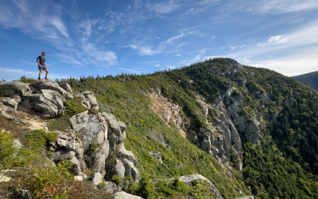
THE OWL — Chris Bennett stands near the summit of The Owl, one of the many peaks of Baxter State Park, on Aug. 20, while camping and hiking in the park with friends.
Coincidentally, I spotted a barred owl while hiking Horse Mountain a few years ago. Conversely, I did not see a horse while hiking The Owl last week. (I’ve yet to hike Black Cat.)
An annual family camping trip led me to Baxter State Park last Tuesday, and I was lucky enough to have a tent site through the weekend. By day five of the trip, I was sunburnt, greasy-haired and smelled like campfire smoke. But my heart was full from time spent with family and friends in the wilderness.
During the trip, I hiked The Owl, South Turner Mountain and Katahdin. I also canoed on Daicey and Kidney ponds, and walked into several other ponds looking for wildlife. That may seem like a lot, but I truly just scratched the surface of all there is to do in Baxter.
The Owl is a wonderful hike for several reasons. Firstly, it offers amazing views of its famous nextdoor neighbor, Katahdin. And in the opposite direction, the view includes a collection of Baxter’s most beloved ponds, including Kidney and Daicey.
ROUNDED SHAPE — Rising over 3,700 feet above sea level, The Owl is one of the most recognizable landmarks in Baxter State Park, with its rounded shape resembling an owl.
The second reason I love The Owl is that the hike is fairly short compared to other mountain hikes in the park. It’s about 3.3 miles from the trailhead to the summit, making for an out-and-back trip of 6.6 miles.
My partner and I started our recent hike of The Owl around 6:30 a.m. and were back by lunch, giving us the rest of the day to swim, nap and canoe.
Don’t get me wrong. It’s a strenuous, rocky climb with over 2,500 feet in elevation gain. But that’s another reason I love it. For people who are thinking of trying to summit Katahdin, The Owl is a perfect warm-up hike to see if you can (or want to) handle that type of rugged terrain.
Parking can be tricky. The hike begins at Katahdin Stream Campground, where you need to reserve a parking space ahead of time. That’s because Katahdin Stream Campground is one of three parking areas for Katahdin, which is an extremely popular mountain to hike.
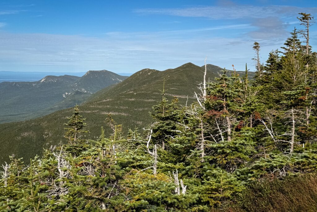
SUMMIT — The summit of The Owl offers open views of nearby mountains on Aug. 20, in Baxter State Park. These mountains include Barren, Doubletop and Morse.
The other option is to stay in the park at a campsite (which you need to reserve ahead of time) and arrive at the trailhead before 7 a.m. That’s what we did.
After signing the trail register at the ranger station – an important step so that rangers can keep track of hikers’ whereabouts – we started our trek on Hunt Trail, which travels all the way to the top of Katahdin. The Hunt Trail is also the northernmost section of the Appalachian Trail, which stretches for 2,200 miles from Georgia to Maine.
As is the case with many mountain trails, the hike started out fairly smooth and gradual at the base of the mountain, then became progressively rocky and steep. At 1.1 mile, we reached a signed trail intersection where we turned left onto The Owl Trail, leaving Hunt behind.
This is just before Hunt Trail reaches a majestic waterfall called Katahdin Stream Falls. So, if you’re particularly ambitious, you can hike a few extra tenths of a mile out and back to the waterfall before heading up The Owl.
You likely won’t encounter many other hikers on your way up The Owl. It’s a hike that’s flown (pun intended) largely under the radar, overshadowed – both literally and figuratively – by Katahdin.
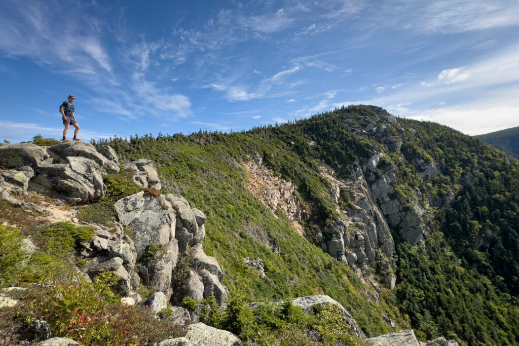
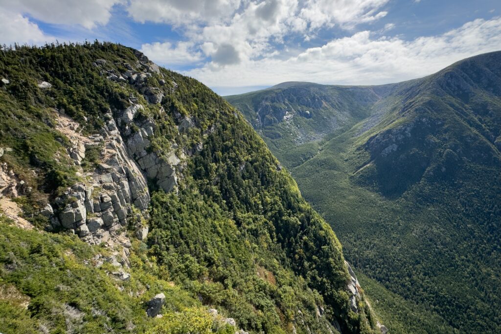
Much of the trail threads through a dense forest filled with lush moss and tall spruce trees. Just before the summit, the trail emerges from the trees to an overlook. This open view includes Katahdin and nearby ponds, plus a nice perspective of a vertical rock face on The Owl that some sources estimate being around 500 feet high.
This overlook can easily be mistaken as the summit (also known as a false summit), but from there, the trail continues about 0.1 mile to the summit, passing through a dense stand of evergreen trees along the way.
The summit is 3,736 feet above sea level, according to my Map Adventures map of the park. However, this number varies depending on the source. Nevertheless, it pops above the trees, offering great views. Over the stunted, weathered spruce trees, the nearby mountains of Barren, Doubletop and Morse march off to the horizon.
When I was there last week, I didn’t see a summit sign, which is a bit unusual for Baxter State Park. Does anyone know why that is?
Alone at the summit, we stretched out on the sun-warmed granite and relaxed for a while before retracing our steps to the trailhead. A swim in Nesowednehunk Stream punctuated a perfect day in the park.