We had unfinished business with the elusive North Peak
By Ron Chase
North Peak of Moxie Bald Mountain was a setback for my son, Adam, and me.
We had hiked Moxie Bald in early November, but failed in an attempt to ascend the elusive North Peak, a summit that was too far from us given the limited fall daylight.
We were also unsuccessful climbing both peaks last winter due to difficulty accessing the trailhead.
That problem was not going to change this coming winter, so we decided to return to North Peak this fall before snow- and ice-covered roads became an impediment.
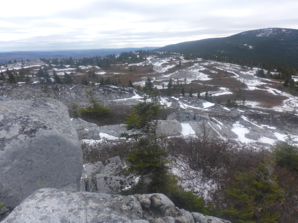
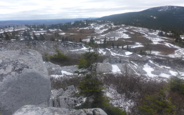
NORTH PEAK SUMMIT — Views from the summit of North Peak are remarkable.
Moxie Bald Mountain and North Peak are located in remote Bald Mountain Township on the east side of Moxie Pond, approximately 12 miles east of Caratunk in Somerset County.
The Appalachian Trail is the only means of hiker access.
As the name implies, North Peak is situated north of Moxie Bald. Supposedly, a spur trail leaves the AT somewhere north of Moxie Bald and leads to the North Peak summit.
We were unable to find it during our previous expedition, but were determined to accomplish our goal this time.
There are no good roads to AT trailheads for the Moxie Bald Peaks. In my opinion, the best of the bad choices is to follow Lake Moxie Road from The Forks to Moxie Pond.

360 — The summit of North Peak provided 360 degree views.
From there, driving south on Troutdale Road along the western shore of the pond brings a hiker to an AT crossing a little south of the pond.
The water level in that area was too high for safe hiking during our earlier visit, so we continued on rutted, rocky, dirt roads to a higher elevation AT crossing.
That was again our plan.
Arriving at Moxie Pond, we were surprised to find the water level substantially lower than on our previous visit because the dam operator had drawn down the pond.
The AT near the southern end of the pond was passable this time. But because the hiking distance to our goal was uncertain, we decided to continue to the loftier AT crossing closer to the peaks.
The mountains had also changed since our prior hike. Snow could be seen on the peaks as we drove south on Troutdale Road. I decided to carry microspikes — ice traction that can be put on boots or shoes.
The trail was free of snow and ice when we began the trek in a hardwood forest. The terrain transitioned to a conifer forest the higher in elevation we went.
A light layer of snow and patchy ice covered the path as we progressed to a junction on the right where the AT continues over Moxie Bald Mountain.
Turning left, we proceeded on the Moxie Bald bypass, a snow-covered rolling passageway. Sporadic views of barren North Peak could be seen shortly before reconnecting with the AT.
Leaving the junction, the trail dropped abruptly into a wet, irregular sector inundated with ice.
Skirting hazardous areas, we began climbing gradually on partially exposed ledges. Soon after, we arrived at North Peak Trail on the left.
Marked with cairns and blue blazes, the spur trail rises gradually on a succession of exposed granite ledges in a sparse conifer forest. The rocky surface was partially covered with ice and snow.
We persisted steadily upward while avoiding obvious slippery areas.
Emerging above the tree line, we encountered a spectacular continuum of enormous granite ledges.
We scrambled up a massive steep sloping escarpment expecting to find the summit. Instead, it was the first of several additional imposing inclines.
During the Moxie Bald expedition, we had sighted a Canada lynx while driving to the trailhead. No lynx this time.
But in a snowy section a little below North Peak summit, we found fresh fisher cat tracks. The secretive predators frequent the area, according to knowledgeable friends.
A climb over a series of precipitous ledges in icy winds brought us to the true summit.
We donned parkas, stocking caps and mittens to protect us from severe wind chills while enjoying fabulous 360-degree views.
We had anticipated an exceptional mountaineering experience, but the expansive exposed summit exceeded even our high expectations.
The harsh wind chills forced us to retreat below the tree line sooner than we preferred. It was difficult to leave such a remarkable alpine setting.
The temperature fell and parkas were needed for the remainder of the hike. We completed our return without complications.
My microspikes were along for the ride. I never used them.
My book, “Maine Al Fresco: The Fifty Finest Outdoor Adventures in Maine” narrates nine more exceptional mountaineering expeditions.