This remote mountain hike has one of the best views in Maine
By Aislinn Sarnacki
The previous night’s rain beaded on fern fronds along the trail. I carefully navigated over slick tree roots, breathing in the rich scents of damp earth, soggy moss and sodden leaves. After a stretch of dry weather, the forest was finally filled with water.
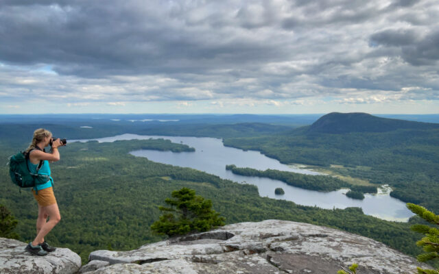
Before long, the short access path ended at the famous Appalachian Trail. There I turned right, following white painted trail markers up the west ridge of Barren Mountain. Rising 2,670 feet above sea level, it’s one of the many peaks traversed by the AT, and an open ledge below its summit offers a breathtaking view of the region.
It had been nine years since I last hiked the mountain. That day, several factors played into my decision to return.
BARREN LEDGES – Bangor Daily News Outdoors contributor Aislinn Sarnacki takes a photo of the view from Barren Ledges on Barren Mountain on Aug. 19, in Maine’s 100-Mile Wilderness.
First, a friend reminded me that it’s a wonderful hike. Second, my dog was in daycare, so I didn’t have to worry about her struggling on the steep, rocky sections. Third, it rained, which meant I might finally find some colorful mushrooms to photograph.
Barren Mountain is the first major peak of Maine’s famous 100-Mile Wilderness, if you’re trekking from the south. The 100-Mile Wilderness is considered the most remote section of the Appalachian Trail. It doesn’t cross any major roads for approximately 100 miles, but parts of it are accessible by side trails and gravel woods roads, if you’ve got good directions and a DeLorme atlas.
As I followed the trail up the mountain, careful not to slip on wet rocks or roots, my breathing quickened. A refreshing breeze swept through the forest as a thick layer of clouds swam overhead.
About 1.5 miles into the hike, I came to a side trail leading to Barren Slide, a cliff and rock slide that offers an open view to the west. Unfortunately, the trail was closed due to peregrine falcons nesting on the cliff. Listed as endangered in Maine, they’re protected, especially during nesting season.
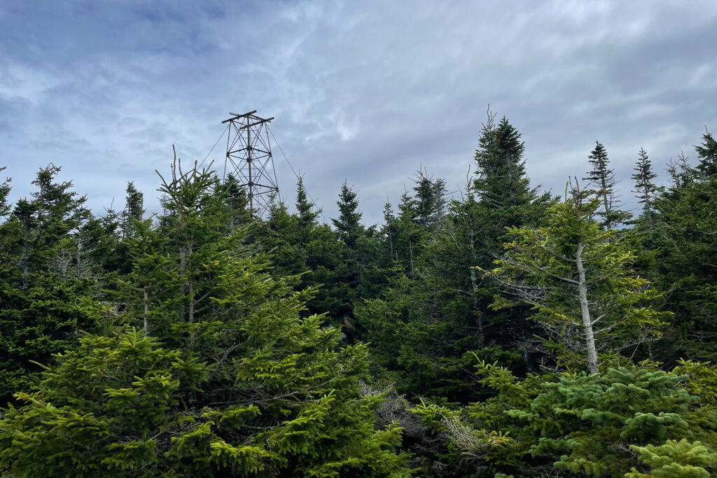
OLD FIRE TOWER – The remains of a fire tower stand atop Barren Mountain in Maine’s 100-Mile Wilderness.
Luckily, farther up the trail, Barren Ledges offers a similar view that is arguably more spectacular. I continued upward to reach that overlook in just a couple tenths of a mile.
Hikers often come together at overlooks. Such was the case that day. I arrived to find a couple of women who planned to camp that night at the nearby Cloud Pond campsite. As we enjoyed the view, chatted and ate lunch, two AT thru-hikers joined us.
“Thru-hiker” is a term used for long-distance hikers — people who are in it for the long haul. They usually carry large backpacks with visible tent rolls and other camping gear, so they’re easy to spot. They also go by special trail names. In this case, they were Beer Lady and Wizard.
As we sat on the open ledge, one hiker noticed two large, dark shapes moving across the surface of Lake Onawa below.
“I think they’re moose,” she said, her voice tinged with excitement.
Indeed, they didn’t move like canoes or any other type of boat, and they were too large to be deer. The leading shape was larger than the second, leading us to believe it was a cow (female moose) and its calf. I only wish I’d had binoculars.
Southwest of us, Borestone Mountain loomed over the lake. Maine Audubon owns and maintains a popular hiking trail to the top of that mountain. I imagined hikers on its summit, staring back at us on Barren.
Beyond, mountains marched across the horizon. The Bigelows and Sugarloaf were among them.
Refueled with a BLT sandwich and an apple, I continued on to the summit. This stretch of the hike included a nice, flattish section through an incredibly mossy forest. The trail even went a bit downhill before the final steep climb to the peak.
Topped with the rusted bones of a fire tower, the summit of the mountain is marked by a classic brown sign created by the Maine Appalachian Trail Club. The club maintains the vast majority of AT in Maine through the work of volunteers. If you’ve ever thought of getting involved, please reach out. It’s a big job. They always could use more help.
The 24-foot steel fire tower is missing its wooden cab, which lies in a dense stand of spruce trees not far away. Did it blow off or was it removed? Online descriptions of the tower state that it’s dangerous to climb, though a steel ladder is still a part of the structure. Fortunately, the trees are so stunted on the peak of the mountain that you can enjoy views without climbing any rusty ruins.
The peak was my turnaround spot. From there, I retraced my steps to the trailhead for a hike that was about 7.5 miles total. But many hikers continue to Cloud Pond, which tacks about 2 miles onto the out-and-back hike. I wasn’t feeling that ambitious.
My mushroom hypothesis ended up being correct. The forest was filled with fungi of all shapes and colors. Ghostly white coral mushrooms sprouted from logs. Yellow-orange mushrooms with round, spotted caps seemed to glow against the deep, velvety moss.
At one point, I passed a little girl who was hiking with her family, and she exclaimed, “I’ve seen so many mushrooms!”
Glad to meet someone who shared my enthusiasm, I asked her if she’d seen any red mushrooms. She said “no,” and I told her to keep an eye out. Farther down the trail, I noticed a mushroom with a bright red cap tucked under the branches of an evergreen tree, so I gathered some small sticks and placed them in the shape of an arrow pointing to the mushroom. The arrow blended in with the forest floor, but if anyone would notice it, it’d be the little girl. I hope she saw it.
Directions: There are two access points to Barren Mountain that I know of — one near Otter Pond and one just before the AT crosses Long Pond Stream. Both require navigating logging roads in areas with little to no cell phone reception.
To reach the Otter Pond trailhead, which I used for this hike, drive to the town of Monson, then turn right onto Elliotsville Road. Drive about 7.6 miles, then turn left onto Bodfish Road (also known as Mountain Road.) Drive about 3 miles, past the Borestone trailhead, and you’ll cross a narrow bridge on private land. Keep going about 0.5 mile, then turn left onto a narrow gravel road. Drive about 0.7 mile to the end of that road and park in a small parking area. (The road is rocky and may not be suitable for some vehicles.) From there, a well-maintained trail leads to the AT. This is on private land, where signs state that day hiking is permitted but overnight parking is not. Keep that in mind when planning your adventure.