8 must-try Maine hikes if you love waterfalls
By Lindsay Putnam, Bangor Daily News Staff
It’s impossible to tire of the beautiful views that await at Maine’s mountain summits.
But sometimes it’s nice to change things up a little.
If you’re looking to take a break from gaining elevation and instead pursue a new goal, here are eight Maine hikes where gorgeous waterfalls await your arrival.
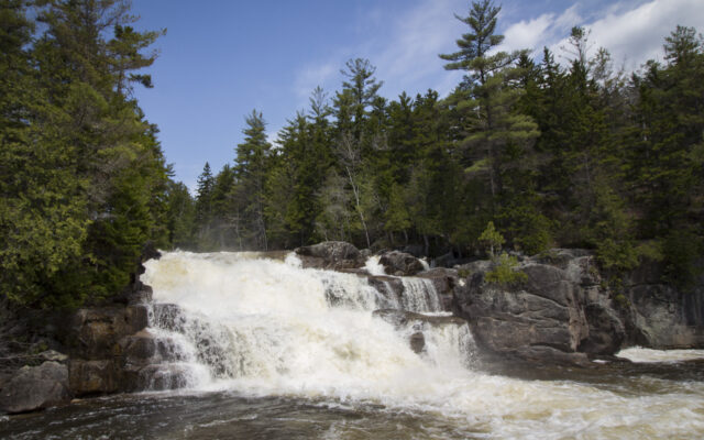
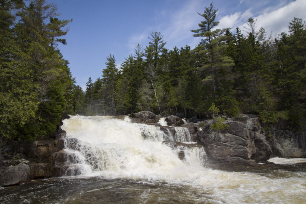
Moxie Falls, near The Forks
Plunging 90 feet into a pool surrounded by ledges, Moxie Falls is one of the tallest and most scenic waterfalls in New England. In the remote township of Moxie Gore, the waterfall is reached by a 1-mile hiking trail that is fairly wide, flat and easy to follow.
As the trail nears the waterfall, the terrain becomes more rugged, with steeper slopes, exposed tree roots and rocky ledges. Watch your step and take care near the ledges. Several wooden bridges and stairs help visitors navigate the terrain to a few wooden platforms strategically located at the edge of the stream above and below the waterfall.
Niagara Falls in Baxter State Park
The Niagara Falls are among the many stunning natural landmarks in Baxter State Park, but only a small percentage of park visitors ever see these waterfalls, even though there are two established hiking trails that lead to them.
The two waterfalls, known as Little and Big Niagara, are located on the Nesowadnehunk Stream just south of Lily Pad Pond. To visit the falls, you can either start at Daicey Pond Campground and hike south on the Appalachian Trail for just over 1 mile, or you can start at Kidney Pond Campground and opt for a lesser-known route that includes a total of 4.6 miles of hiking and about a mile of paddling a park canoe on fairly quiet water.
BIG NIAGARA FALLS – Big Niagara Falls is seen from an outlook on Windy Pitch Pond Trail in Baxter State Park.
Ledge Falls in Baxter State Park
Ledge Falls, also known as “The Ledges,” is a popular swimming spot in Baxter State Park. In this spot, Nesowadnehunk Stream has worn the rock into several smooth natural water slides.
Swift currents, rapids and small waterfalls make this section of Nesowadnehunk Stream exciting, but there are small natural slides and calmer areas of shallow water for children to enjoy under supervision. There’s also plenty of space for sunbathing and relaxing on the rock ledges.
Orin Falls in Katahdin Woods and Waters
Most of the 6-mile, out-and-back hike follows an old logging road, with the last leg of the hike turning onto a narrow woodland trail that leads to the edge of Wassataquoik Stream at Orin Falls, a series of cascades and rapids tumbling around large granite boulders.
Orin Falls, though no great waterfall, is a sight to behold. The clear water of the Wassataquoik Stream churns and tumbles around and over granite rocks and boulders that have been rounded by erosion into smooth, organic shapes. Boulders larger than cars are scattered throughout the stream, along with smaller boulders perfect for rock hopping.
Gulf Hagas near Brownville
Known as the “Grand Canyon of Maine” or the “Grand Canyon of the East,” Gulf Hagas is a slate gorge carved out by the West Branch of the Pleasant River near Brownville. Over the course of 3 miles, the river drops about 500 feet, forming several spectacular waterfalls and swimming holes. In some places, the rock walls that border the river are more than 100 feet tall.
Not everyone who hikes to the waterfalls of Gulf Hagas completes the entire loop, which is 8.6 miles if you start from the east trailhead (Gulf Hagas Parking Area) or 9 miles if you start from the west trailhead (Upper Gulf Parking Area). Two cut-off trails give you the option of completing shorter hikes.
To visit the many waterfalls and swimming holes of Gulf Hagas, hikers must hike into the Rim Trail, which is 3 miles long and visits Screw Auger Falls, Lower Falls, Hammond Street Pitch, The Jaws, Buttermilk Falls, Stair Falls, Billings Falls and the Head of the Gulf.
Mariaville Falls in Mariaville
Located in the Mariaville Falls Preserve, the 0.85-mile Fisherman’s Trail starts at a gravel pit and descends a slope to the West Branch of the Union River. The trail then turns right to travel upriver to Mariaville Falls. Along the way, the trail visits several viewpoints along the scenic river. The trail also travels up and over hills and along the side of a steep slope. At the falls, there is a rough side trail that people can take to access the water at the bottom of the falls.
Peter’s Brook Trail in Blue Hill
This easy-moderate 1-mile out-and-back trail travels through a forest composed mostly of conifers with a few oak trees scattered throughout. A few informal side trails here and there will bring you down to the edge of the water, where you can view several tiny waterfalls and churning pools.
The trail ends at a waterfall that is certainly a sight to behold. There, whitewater tumbles down over a steep set of natural rock steps to plunge into a calm shallow pool below.
Little Wilson Falls, near Elliottsville
Little Wilson Falls is a series of three waterfalls on Little Wilson Stream as it flows through a dramatic slate gorge in Elliottsville Township. A 3-mile out-and-back hike leads to the largest of these waterfalls, which is known as the “upper falls” and is located on the Appalachian Trail.
The lower falls are 18 feet tall, the middle falls are 25 feet tall and the upper falls are the tallest at about 40 feet tall.
LITTLE WILSON FALLS – The upper falls of Little Wilson Falls in Elliottsville Township are about 40 feet tall. The water plunges down into a dramatic slate gorge with almost vertical walls.