Katahdin’s Hamlin Ridge is a lesser-known hiking gem
Difficulty: Very strenuous. Hamlin Ridge Trail climbs to Hamlin Peak, which tops off at 4,756 feet above sea level and is one of Katahdin’s lesser peaks. The trail is rocky, steep and requires some hand-over-foot climbing to navigate around and over large boulders. Though only 1.5 miles long, Hamlin Ridge Trail must be reached by hiking on other trails, so expect a full-day hike. A popular route is a loop hike that includes Chimney Pond, Saddle, Northwest Basin and Hamlin Ridge trails, measuring about 10 miles.
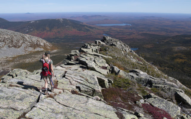
Photo courtesy of Derek Runnells
HAMLIN RIDGE — Bangor Daily News reporter Aislinn Sarnacki hikes along Katahdin’s Hamlin Ridge on Sept. 25 in Baxter State Park.
Information: The tallest mountain in Maine, Katahdin features a long ridge that curves around multiple basins and features a number of peaks or highpoints. North of the mountain’s summit, Hamlin Peak and Hamlin Ridge are lesser-known destinations on the mountain, offering stunning views and a quiet alpine experience.
Hamlin Ridge Trail follows the rocky spine of Hamlin Ridge, which extends from Hamlin Peak east between Great Basin and North Basin. (Basins are bowl-shaped, large-scale depressions in the land.) The ridge is covered with large, angular granite boulders, making footing tricky. In addition, the trail passes by a few ledges that may be intimidating to hikers who struggle with heights.
The ridge offers an amazing view of the Great Basin and South Basin, where Chimney Pond is clearly visible, cradled in the arms of Katahdin. It also offers views of the North Basin, with its nearly vertical rock faces. Most trails on Katahdin don’t offer any views of this basin.
Also from the ridge, hikers can easily spot the nearby Basin Ponds, South Turner Mountain, Katahdin Lake and the smaller peaks within Katahdin Woods and Waters National Monument.
Far from roads and parking areas, Hamlin Ridge Trail can only be reached by hiking other trails within Baxter State Park. Regardless of the route you select, you’ll need to park at Roaring Brook Campground and start your hike on Chimney Pond Trail.
If you want to hike up the Hamlin Ridge Trail, you’ll hike on the Chimney Pond Trail for about 2.3 miles, then turn right onto the North Basin Cut-off Trail. In 0.7 mile, you’ll turn left onto the North Basin Trail, which leads to the Hamlin Ridge Trail in 0.2 mile. From there, you can climb up the Hamlin Ridge Trail for 1.3 mile to Hamlin Peak. You can then head back down the way you came for a 9 mile out-and-back hike. Or you can make it into a loop hike.
For a loop hike, continue past the peak on the Hamlin Ridge Trail for 0.2 mile, then turn left onto the Northwest Basin Trail. Follow that for 0.9 mile through a beautiful alpine habitat of low-bush blueberries and other shrubs and grasses, dotted with lichen-encrusted granite boulders. You’ll cross over onto what’s known as Katahdin’s Table Land, which is relatively flat, then come to an intersection with the Saddle Trail. Turn left onto the Saddle Trail to steeply descend Katahdin.
The Saddle Trail — known for its rose-colored granite rock slide — will bring you to Chimney Pond in 1.2 miles. At 2,914 feet, the pristine pond is home to a campsite and ranger station and offers one of the most iconic views of Katahdin. From there, hike 3.3 miles on the gradual, forested Chimney Pond Trail back to Roaring Brook Campground. This loop hike is 10.1 miles long.
On the advice of a friend, I did this route in the opposite direction so I could hike down the Hamlin Ridge Trail, enjoying views the whole way. (When you hike up a ridge or slope, you’re often looking at the rock ahead and sometimes forget to look back at the views.) I enjoyed hiking it in that direction, though it did require a lot of squatting and sitting down to safely navigate down over the boulders. (Saddle Trail is a gentler descent in that respect.)
To navigate the many trail intersections, I suggest carrying a detailed trail map, such as the Baxter State Park map created by Map Adventures, a Maine-based company.
Hamlin Peak and Hamlin Ridge are named after geologist Charles E. Hamlin, a professor of geology at Harvard who visited Katahdin multiple times in the late 1800s to study the mountain. He was also one of the original members of the Appalachian Mountain Club. In the club’s journal, Appalachia, he published the 1881 article, “Routes to Ktaadn,” which was accompanied by one of the first maps of the mountain.
Dogs are not permitted in Baxter State Park. Entering the park for day use is free for vehicles with Maine license plates, and $15 for vehicles without Maine license plates. Reservations are required for camping. You may also want to reserve a parking spot if hiking Katahdin, since parking lots fill up quickly.
For more information, including how to reserve a parking spot, visit baxterstatepark.org or call 207-723-5140.
Personal note: After hiking to Hamlin Peak on Sept. 25, my husband Derek and I decided that it’s one of our favorite hikes in Baxter State Park. The route offered the excitement of climbing Katahdin while also veering off the well-trodden path so we could enjoy the mountain in relative solitude.
While certainly a high point of the mountain, Hamlin Peak is so rounded and wide that it’s easy to miss if you aren’t looking for it. Located at a trail intersection, it’s marked with several signs. On Sept. 25, those signs were so badly weathered we could barely make out the writing, but with our map we confirmed we were indeed at the peak. (Park rangers are constantly replacing the signs as they’re eaten away by harsh weather conditions.)
I often find descending Katahdin to be a lot less exciting than climbing it. At that point in the hike, I’m usually tired, my feet hurt and I’m eager to be back at camp, sipping a cold beverage. But the spectacular views from Hamlin Ridge, enhanced by the colorful fall foliage, reinvigorated us both and made the descent seem much shorter than usual.
How to get there: Travel on I-95 to Exit 244, then turn west on Route 157 and travel through Medway, East Millinocket and Millinocket. Drive straight through two traffic lights in downtown Millinocket, then bear right at a three-way intersection, then bear left at the next “Y” intersection, staying on the main road. (Along the way will be signs directing you to Baxter State Park.) Drive about 16 miles to the Togue Pond Gatehouse. (The blacktop road turns to gravel soon before the gatehouse.)
After registering at the gatehouse, veer right at the Y intersection and drive about 7.9 miles to Roaring Brook Campground, which is located at the end of the road. At the campground is very limited day parking, as well as parking for registered campers. Register at the ranger station, then begin your hike on Chimney Pond Trail.
Aislinn Sarnacki can be reached at asarnacki@bangordailynews.com. Follow her on Twitter: @1minhikegirl, and Instagram: @actoutdoors. Her guidebooks “Family Friendly Hikes in Maine,” “Maine Hikes Off the Beaten Path” and “Dog-Friendly Hikes in Maine” are available at local bookstores and wherever books are sold.