Baxter State Park offers many spectacular mountain hikes beside Katahdin
Each summer, hikers flock to Katahdin, the tallest mountain in Maine. It’s the most popular destination in Baxter State Park, and for good reason. But it may not always be the best hiking option for you.
Maybe you aren’t ready for such an arduous climb. Maybe you don’t have the time for the full-day trek. Or maybe the Katahdin trailhead parking lots are full — something that happens a lot.
Fortunately, there are many other spectacular mountains in the park to hike. Baxter is home to more than 220 miles of hiking trails. And believe me, they’re all wonderful.
Each year, my family camps and hikes in Baxter. During those trips, I’ve hiked Katahdin several times. I love that mountain, as many people do. But it’s not always the best option for me. In fact, on a recent trip to the park, I decided against hiking Katahdin because I didn’t feel up to it mentally or physically. Instead, I pulled out my Baxter State Park trail map, and after some consideration, my finger landed on Mount OJI.
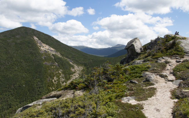
Bangor Daily News photo/Aislinn Sarnacki
MOUNT OJI — Mount OJI is one of the many mountains that can be explored by hiking trail in Baxter State Park. This is a view from its open ridge.
My husband, Derek, joined me that day, and we enjoyed spectacular views of the park. Compared to Katahdin, OJI was certainly an “easier” hike. Still, I was drooping from exhaustion by the time we returned to the campground, and I knew we’d made the right choice.
So if you’re worried that Katahdin might not be the right hike for you, for whatever reason, here are a few other mountain hikes in Baxter State Park, starting with the magnificent OJI. All of these treks offer spectacular views of the park. Click on the links for videos and more information about each hike.
Mount OJI
Mount OJI rises 3,434 feet above sea level. Hiking to the top and back is 8 to 9 miles, depending on whether you hike all the way to the summit or simply turn around at the best open views, which are along the ridge by a landmark called Old Jay Eye Rock. The mountain was named after distinct rock slides that scar its side. Though they’ve shifted over the years, they used to resemble the letters O, J and I.
Doubletop Mountain
Doubletop Mountain features two distinct peaks, with the highest at 3,488 feet above sea level. A trail travels up and over the mountain, with trailheads on both ends. Therefore, the hike can vary in length from 6.6 miles and 7.6 miles, depending on which trailhead you start from — and which trailhead you end at. This is often referred to as a great “practice climb” for those who are looking to hike Katahdin.
The Owl
The Owl rises approximately 3,736 feet above sea level and is right beside Katahdin. The hike is 7.4 miles total and includes scrambling over boulders and struggling up steep, rocky sections of trail. It’s believed that it was named after its dome profile, which resembles a sitting owl.
South Turner Mountain
South Turner Mountain rises 3,122 feet above sea level and is known as one of the most rewarding short climbs in Baxter State Park. Out and back, the hike is 4 miles, and the top offers a 360-degree view of the park, including one of the most stunning views of Katahdin. In addition, this hike passes along the shore of Sandy Stream Pond, a place that’s frequented by moose.
Sentinel Mountain
Sentinel Mountain rises 1,842 feet above sea level, making it one of the shortest named peaks in Baxter State Park. Yet several overlooks near its top offer spectacular views of the region, including a front-and-center view of nearby Katahdin. Out and back, the hike is 6.2 miles, with much of it over rugged but relatively level terrain.
Mount Coe and South Brother
Mount Coe-South Brother Loop (also known as the Marston Loop) travels to the summit of two mountains. Mount Coe rises 3,795 feet above sea level, while the nearby South Brother Mountain rises 3,970 feet. This challenging loop hike is 8.1 miles long. And if truly ambitious, you can add onto this loop the 1.6-mile out-and-back trail to the top of North Brother Mountain, which is 4,151 feet above sea level. This would lengthen the total trek to 9.7 miles.
North Traveler Mountain
North Traveler Mountain rises 3,144 feet above sea level and is located in the northern half of Baxter State Park. This mountain offers views early in the hike, which is 5.6 miles, out and back. Hikers can also extend their hike by continuing on the trail to visit nearby peaks called The Traveler and Peaks of the Ridges. This 10-mile Traveler Loop is thought to be just as difficult as Katahdin, if not harder.
Trout Brook Mountain
Trout Brook Mountain rises 1,767 feet above sea level on the north end of Baxter State Park. The mountain features a 3.3-mile loop hike that leads to great views of the nearby Traveler Mountains and Grand Lake Matagamon.
Horse Mountain
Horse Mountain rises 1,589 feet above sea level, making it one of the smaller mountains in the park. However, from a bald outcropping on its eastern side, hikers are rewarded with a wide open view of the mountains in the north end of the park. Out and back, the hike is about 3 miles.
Aislinn Sarnacki can be reached at asarnacki@bangordailynews.com. Follow her on Twitter: @1minhikegirl, and Instagram: @actoutdoors. Her guidebooks “Family Friendly Hikes in Maine,” “Maine Hikes Off the Beaten Path” and “Dog-Friendly Hikes in Maine” are available at local bookstores and wherever books are sold.