Paddlers enjoy stunning views of Katahdin, abundant wildlife on Millinocket Lake
Difficulty: Easy to strenuous, depending on how much of the lake you explore and the weather conditions. Millinocket Lake is fairly large, covering nearly 9,000 acres. You could easily paddle over 10 miles and not see everything.
Information: Dotted with boulders and small islands, Millinocket Lake is a large body of water that lies just south of Baxter State Park, providing stunning views of Katahdin and other mountains within the park.
A lake bearing the same name lies just north of the park. For this column, I’ll be focusing on the southernmost of the two.
“As in many of Maine’s lakes formed by glacial action, rockiness is the outstanding feature of Millinocket Lake,” according to a survey of the lake conducted by the Maine Department of Inland Fisheries and Wildlife in 1954 and revised in 1979. “The extensive rocky shoreline is punctuated by numerous coves, peninsulas and rocky shoals. Many small islands are scattered throughout the shallower areas of the lake.”
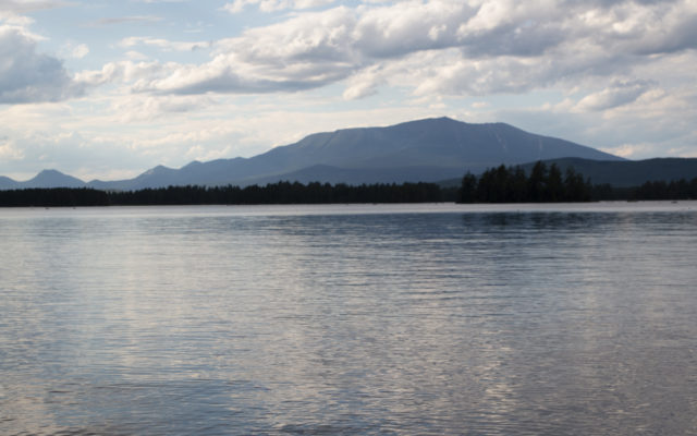
Bangor Daily News photo/Aislinn Sarnacki
MILLINOCKET LAKE — Katahdin rises above Millinocket Lake in the Katahdin region, with smaller mountains in Baxter State Park, such as Doubletop Mountain, also visible.
While navigating can be difficult in some areas due to an abundance of large submerged rocks, the lake is a popular place for paddling, fishing, swimming and wildlife watching. On the southwest end is the public boat launch, as well as houses and a campus that’s home to Twin Pines Cabins, River Drivers Restaurant and the New England Outdoor Center. More houses and camps are scattered along the south shore and up the eastern side of the lake, with wilderness prevailing along the northern and western shoreline.
Several streams and brooks flow into the lake, creating areas that are great for wildlife watching. In fact, a NEOC wildlife tourboat often visits Big Mud Brook on the lake’s north end in search of moose, loons, beavers and other wild animals. Also on the lake’s north end are a few sandy beaches where recreators frequently stop to sunbathe, swim and picnic. Paddlers also stop on some of the small, undeveloped islands, where flat-topped boulders make for good seating areas.
The lake is home to a wide variety of fish, including landlocked salmon, brook trout, lake trout, white and yellow perch and chain pickerel. While some areas of the lake are especially shallow, there’s also some deep water, with a greatest depth of 86 feet.
Millinocket Lake shares its name with the nearby town of Millinocket, which lies just south of it.
The word “Millinocket,” in the language of Maine’s Abenaki people, roughly translates to “land with many islands,” according to a brief history of the town provided online by the Millinocket Historical Society.
Personal note: A quiet afternoon paddle was just the thing my husband Derek and I needed on July 29 during a weeklong family vacation at Twin Pines Cabins on Millinocket Lake. After signing a waiver to use a rental canoe, we launched from a small, sandy beach that’s a popular swimming spot for guests. A steady breeze stirred small waves on the surface of the large lake, and thick clusters of fluffy clouds scuttled across the sky.
Always eager to view wildlife, I proposed we paddle along the western shore of the lake, dipping in and out of quiet coves where aquatic plants grow in abundance. In one such indentation along the shore, we were rewarded by the distinctive rattle of several belted kingfishers. One of my favorite lake birds, the kingfisher is a speedy flyer with a long sharp beak that it uses to snatch up prey. They can often be found perched on dead tree limbs near the shore, where they look down into the water in search of fish. They’re also one of the few bird species in which the female is actually more colorful than the male, with rust-colored patches on her chest.
In another cove, we were greeted by grunts of green frogs. A family of common mergansers maneuvered around clusters of wide floating leaves and bulbous yellow flowers of spatterdock. The mother duck led a group of nine ducklings. Or maybe it’d be more accurate to call them duckteens. They were already well on their way to adulthood, with the same brown head and gray body as their mother — just smaller.
A variety of water plants added to the beauty of the scenery. In one cove, oval floating leaves of a plant called watershield crowded together, creating a patchwork of green and maroon. In another area, long blades of what appeared to be aquatic grass laid flat on the surface of the water in long stripes. Our eyes were also drawn to the many boulders protruding from the water. We dubbed one especially large boulder “sharktooth” due to its pointed shape.
Circling around some small islands, we spotted two loons. And a few days later, on another canoe trip, we spotted four loons — all swimming close together. On that second trip, we were accompanied by my mother, sister and niece, and our goal was to find somewhere to eat lunch. We circled around several islands before finding a quiet spot on some flat rocks, with a sandy pool in the shallows nearby. It was a hot day, so my sister and I sat right in the water to cool off while the others perched on rocks to dip their feet in. Before long, we’d attracted a group of small fish, which seemed to enjoy nibbling on our toes. I believe they were some sort of sunfish, based on their general shape and the dark spot they bore on each side.
On both trips, we likely traveled between 4 and 6 miles. It’s hard to say, with all the meandering we did around the islands and into the coves. The views were spectacular and the water clear. Someday we’ll make it all the way to the sand beach on the north end.
How to get there: A public boat launch is located at the southwest end of the lake, off Fire Road 21. (Latitude: 45.73051, longitude: -68.83611) To get there, take Exit 244 off Interstate 95. Turn west onto Route 11-Route 157 and drive 11 miles through the towns of Medway and East Millinocket to Millinocket. In downtown Millinocket, continue on Route 157, following signs to Baxter State Park. About 8.7 miles from the intersection of Katahdin Avenue and Central Street in downtown Millinocket, turn right onto Fire Road 21, a gravel road that’s about 500 feet past North Woods Trading Post. Drive about 400 feet, then veer right and the boat ramp is right there, along with a turnaround and plenty of space to park.
Aislinn Sarnacki can be reached at asarnacki@bangordailynews.com. Follow her on Twitter: @1minhikegirl, and Instagram: @actoutdoors. Her guidebooks “Family Friendly Hikes in Maine,” “Maine Hikes Off the Beaten Path” and “Dog-Friendly Hikes in Maine” are available at local bookstores and wherever books are sold.