These new Katahdin-area mountain bike trails are top notch
Difficulty: Easy to moderate. The Hammond Ridge Trail System currently includes about 6 miles of single-track mountain bike trails, which are smooth-surfaced and feature many turns and interesting features such as small jumps. These trails vary somewhat in difficulty. On the trail map, the 4-mile Katahdin Area Trails Loop trail is labeled in green as “easy,” while some connecting trails are labeled in blue as “more difficult.” These single-track trails intersect with wide, gravel-based cross-country ski trails, which are open to biking and hiking as well.
Information: The Hammond Ridge Trail System is an expanding trail network for mountain biking, cross-country skiing and hiking located just outside Millinocket on Black Cat Mountain and Hammond Ridge. The trail network opened in 2019, with the first 6 miles of the trails complete and more planned for the future.
The trail network was constructed by Katahdin Area Trails, a nonprofit organization that was founded in 2014 to bolster the economy of the Katahdin region through the development of sustainable, world-class mountain biking and cross-country ski trails and facilities. The end goal is to develop at least 75 miles of mountain biking trails and 30 miles of cross-country ski trails in the area, including a trail that extends all the way to Millinocket, about 8 miles away.
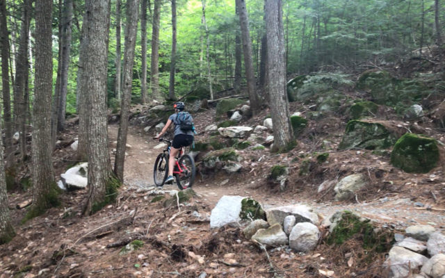
Photo courtesy of Derek Runnells
Bangor Daily News reporter Aislinn Sarnacki bikes along a section of the Katahdin Area Trails Loop on July 31 in the Hammond Ridge Trail System just outside Millinocket.
Starting at the Millinocket Lake Trailhead off Twin Pines Road, a single wide trail enters the forest to quickly lead to the KAT Loop, a single-track mountain biking trail that totals about 4 miles and forms a loop.
The term “single track” is used to describe a type of mountain biking trail that is approximately the width of a bike. This type of trail does not allow bikers to easily pass one another. Passing often involves one person stopping and moving to the edge of the trail.
The KAT Loop is considered to be a fairly wide single-track trail, measuring between 3 and 4 feet wide. This makes it a bit less intimidating for beginners, since there is some room to maneuver back and forth without going off trail. The trail is surfaced with locally-sourced crushed shale mixed with hardpan soil, making the ride very smooth, with just a few rocks here and there.
The loop crosses over ski trails in a number of places. Small, green “KAT Loop” signs mark the intersections, helping bikers stay on the right course. In addition, small orange signs direct trail users back to the trailhead at the northern end of the trail network. Nevertheless, you may want to carry a trail map when first exploring.
If biking the loop counter clockwise, you’ll start by traveling partially up the northeast slope of Black Cat Mountain. You might not even notice that you’re gaining elevation — from 480 feet above sea level to 640 feet above sea level — because the climb is so gradual with many turns, flat stretches and even some downhill portions. You’ll then follow the trail over to the western slope of Hammond Ridge, where you’ll climb just a bit higher, to about 700 feet above sea level, before zigzagging downhill, back to 480 feet above sea level. This down slope is gradual but noticeable. You’ll need to use your brakes to safely execute some of the many turns.
Nearing the bottom of the hill, at about 560 feet above sea level, a single-track trail called KAT Shortcut veers off to the left. This will bring you directly to Blackcat Road, where you can turn right for an easy ride back to the trailhead. The KAT Shortcut also leads to a more challenging single-track trail that winds through the forest and also leads toward the trailhead.
Much of the trail travels through a beautiful forest, filled with large trees, mushrooms and boulders. However, some stretches of the trail at higher elevations strike through more open, grassy areas, where you can enjoy a bit of sun.
The single-track trails were designed specifically for mountain biking, with interesting features that include wide wooden bridges, berms (banked corners that make turning fast easier and more fun), and small man-made bumps that can be used as jumps. Many of these features were added just this past June.
In addition, the trails were designed by the International Mountain Bike Association to be environmentally and economically sustainable, with carefully planned drainage structures that prevent erosion and the collection of water. Construction was overseen by local mountain bike trail expert Josh Tauses, who is the force behind the vast network of mountain bike trails in Carrabassett Valley.
Fat-tire mountain bikes are available for rental at the New England Outdoor Center base and River Driver Restaurant across the road from the trailhead. They are $15 per hour, $40 for half a day and $60 for a full day. For more information, call 800-766-7238 or visit neoc.com/bike/.
Personal note: During a recent family vacation at Twin Pines on Millinocket Lake, my husband Derek and I took the opportunity to ride our mountain bikes multiple times on the nearby Hammond Ridge Trail System. It was a great way to warm up before jumping in the lake for a swim.
I still consider myself a beginner mountain biker, and I found the KAT Loop to be a fun challenge. The uphill portions got my heart pumping, and the many twists and turns improved my steering skills. I appreciated the smooth surface of the trail, as I don’t particularly enjoy riding over lots of tree roots and rocks.
Derek, who has much more experience mountain biking than me, could zip around the loop a lot faster. As I pedaled behind him, I noticed that he would often execute little jumps, launching off the small, man-made features built of rocks and soil. In fact, there were places where the trail split so I could choose the easier route while he launched off a jump.
Due to the concentration required to mountain bike (and not crash into a tree), I didn’t have the opportunity to stop and smell flowers like I do when hiking — quite literally. But I did stop to photograph some especially flashy mushrooms, including some orange toadstools covered with white spots and large shelf mushrooms called artist’s conk.
Mountain biking, for me, is similar to archery. Both sports require intense concentration that leaves no room for outside thoughts. Because of that, mountain biking can be incredibly relaxing — which is an odd concept, considering it involves hurtling through the forest on two wheels.
How to get there: A large gravel parking area for the trail system is located directly across the road from River Drivers Restaurant and the campus for Twin Pines Cabins and the New England Outdoor Center on Millinocket Lake. The physical address is 30 Twin Pines Road in Millinocket, though it’s technically within a nearby township called T1 R8 WELS. To get there, take Exit 244 off Interstate 95. Turn west onto Route 11-Route 157 and drive 11 miles through the towns of Medway and East Millinocket to Millinocket. In downtown Millinocket, continue on Route 157, following signs to Baxter State Park. About 8 miles outside of town, turn right onto Blackcat Road. Drive about 1 mile and the parking lot for the trail system on your right.
Aislinn Sarnacki can be reached at asarnacki@bangordailynews.com. Follow her on Twitter: @1minhikegirl, and Instagram: @actoutdoors. Her guidebooks “Family Friendly Hikes in Maine,” “Maine Hikes Off the Beaten Path” and “Dog-Friendly Hikes in Maine” are available at local bookstores and wherever books are sold.