Allagash Lake to Indian Stream
Are you up for an exciting nontraditional canoe trip within the Allagash Wilderness Waterway (AWW)? The Allagash Lake to Indian Stream adventure takes in the most remote and historic sections of the waterway. Allagash Stream is one of my favorite stretches of the entire AWW. It features small water canoeing with a surprise around every bend in the stream.
You start this journey by putting in at Johnson Pond or Upper Allagash Stream. I prefer the upper stream access point because you can drive within a few feet of the watercourse, launch your canoe and be underway without much difficulty. Johnson Pond to Upper Allagash Stream is another option for this trip but the brook from Johnson Pond can be a challenge when the water gets low.
It is about a four-mile paddle down to Allagash Lake either way you go. Just about the time you start thinking where is this lake, it will come into view. Allagash lake is arguably the most beautiful of all the AWW headwater lakes. It is, without a doubt, the quietest of the waterway lakes, no motors or power equipment of any kind is allowed on Allagash Lake or Stream. In fact, the use of motor vehicles within one mile of Allagash Lake is prohibited from May 1 to Sept. 30.
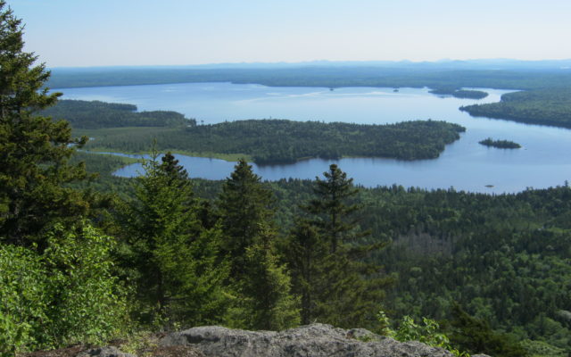
When you get to Allagash Lake, you will be impressed with the size of this waterbody. It is over 151,000 acres in size and has a maximum depth of 89 feet. The lake has an ample population of native brook trout and lake trout (togue). It generally has very good fishing throughout the summer, and is especially good in the spring and fall.
There are 14 beautiful, well maintained campsites on the lake and a nice one mile hiking trail up to the Allagash Mountain fire tower. The tower is no longer staffed, but it is open to the public and offers spectacular views of the surrounding forest, lakes and ponds. The trail up to the tower starts in the southwest corner of the lake, at the ranger station.
As you leave Allagash Lake, you will notice the remnants of an old log driving dam at the outlet- this is a good spot to try your luck at fishing. The stream moves along nicely, but not difficult, for about three miles to Little Round Pond. This is one of the most remote spots on the waterway. Moose, eagle and other wildlife sightings are common at Little Round Pond.
The stream drops 12 feet over a ledge outcropping at the outlet of the pond. The portage trail is on river left at the campsite. If you can work it into your trip itinerary, I would recommend staying overnight at Little Allagash Falls. The falls is one of the most beautiful natural spots on AWW!
After Little Allagash Falls, there are three small ledge drops that can be run by an experienced canoeist, these drops should be scouted before attempting to navigate.
About a mile below Little Allagash Falls, is a bridge that crosses the stream. There is a big standing wave just below the bridge that can be run if the water is not too high, scout this drop from the bridge. Below the bridge, the stream slows down and eventually becomes flatwater as you enter Chamberlain Lake.
Nestled in the northeast corner of Chamberlain Lake is the Tramway Historic District, a must-see location for anyone interested in the logging history of Maine. See www.maine.gov/allagash for more information on the Tramway Historic District. You can portage to Eagle Lake at the tramway or continue down the lake to Lock Dam for a much shorter portage. There is a nice three party campsite at Lock Dam, this is the last campsite before the takeout at Indian Stream.
Below Lock Dam you will enter Martin Stream, it is about a third of a mile to Eagle Lake. Once you enter the lake you will head southeast for about two miles, Indian Stream enters Eagle Lake at the most southeasterly cove on the lake. You will need to wade your canoes up Indian Stream, about 800 feet to the parking lot. I took out at Indian Stream last year, it seems like a lot longer than 800 feet!
This canoe trip could be completed in as little two days, but I would recommend that you disconnect from your electronic devices, take your time and enjoy the Allagash Wilderness Waterway.
Waterway notes: The AWW will be replacing the outlet structure at Lock Dam in late summer/early fall. The water will be drawn down earlier than normal in Chamberlain and Telos Lakes to accommodate this project. The campsites at Lock Dam will be closed and canoeists will have to portage the 2,000 feet from Chamberlain to Eagle Lake during the construction period.
Landvest will be rebuilding the bridge on the American Reality Road, where it crosses the waterway at Umsaskis, during August and September. During this time, the bridge will be closed. Access to the ranger station and canoe launch will be via Churchill Dam or Clayton Lake during construction.